The Korean Peninsula is located in North-East Asia. It is bordered by the Amnok River (Yalu River) to the northwest, separating Korea from China, and the Duman River (Tumen River) to the northeast which separates Korea from both China and Russia. The country itself is flanked by the Yellow Sea to its west and the East Sea to the east. There are several notable islands that surround the peninsula including Jejudo, Ulleungdo and Dokdo.
The Korean peninsula is roughly 1,030 km (612 miles) long and 175 km (105 miles) wide at its narrowest point. Korea's total land area is 100,033 sq km, and it has a population of 49.8 million people (2011).
Because of its unique geographical location, Korea is a very valuable piece of land and an international hub of Asia.

Season
Korea's climate is regarded as a continental climate from a temperate standpoint and a monsoonal climate from a precipitation standpoint. The climate of Korea is characterized by four distinct seasons: spring, summer, fall, and winter.
Summer
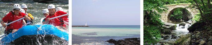
The hot months of summer last from June to early September. Half of the annual rainfall occurs during the monsoon season from late June to early July. Mid-July through mid-August is the hottest period and the most popular time for Koreans to go on vacation.
The National Flag of Korea
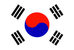 |
The Korean flag (태극기) is called "Taegeukgi" in Korean. Its design symbolizes the principles of the yin and yang in Oriental philosophy. The circle in the center of the Korean flag is divided into two equal parts. The upper red section represents the proactive cosmic forces of the yang. Conversely, the lower blue section represents the responsive cosmic forces of the yin. The two forces together embody the concepts of continual movement, balance and harmony that characterize the sphere of infinity. The circle is surrounded by four trigrams, one in each corner. Each trigram symbolizes one of the four universal elements: heaven ( |
The National Flower of Korea
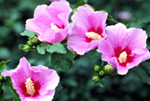 |
The national flower of Korea is the mugunghwa (무궁화), rose of sharon. Every year from July to October, a profusion of mugunghwa blossoms graces the entire country. Unlike most flowers, the mugunghwa is remarkably tenacious and able to withstand both blight and insects. The flower’s symbolic significance stems from the Korean word mugung, meaning immortality. This word accurately reflects the enduring nature of Korean culture, and the determination and perseverance of the Korean people. |
Language
Hangeul (한글), Korea’s official alphabet, was first invented by King Sejong during the Joseon Dynasty. Originally called Hunminjeongeum (훈민정음), the language was conceived in 1443, and further promulgated by the King in 1446. At the time of its inception, the language consisted of 17 consonants and 11 vowels however, since then, 3 of the originally established consonants and 1 vowel have fallen into disuse bringing the total number of characters to 24. Syllables are formed by the selective combination of vowels and consonants to create words.
About Seoul
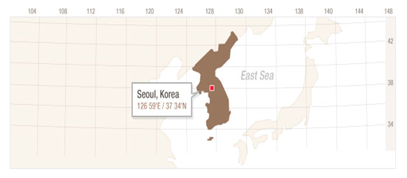
| Location | Located at 126 59' E and 37 34' N, Seoul is at the heart of the Korean Peninsula. The city is nearly equidistant from the southeastern port of Busan and the northwestern town of Sinuiju on the China-North Korea border. The city is also conveniently located in the middle of several major northeast Asian metropolises, such as Tokyo, Beijing, Shanghai and Taipei. The city is some 30.3 km from north to south and 36.78 km east to west. Its total area is 605.41 square kilometers, making it a truly large metropolis. |
|---|---|
| Population | 10,528,774 people (foreign population: 279,000) |
Natural Environment Surrounded by Mountains and Rivers
To the west of the city is the Gyeonggi Province, one of Korea's largest flatland areas and one of the country's most agriculturally productive regions. Hangang bisects the city east to west, flowing in a broad "W" pattern. In the old days, the river was home to flourishing river ports at Mapo and Ttukseom and the ferry terminals at Noryangjin, Yanghwado, Hannamdo, Songpado and Gwangnaru. However, with the development of overland transportation and the construction of large bridges across the river, the city's ports and ferries have disappeared.
Meanwhile, silting along the lower reaches of Hangang has created a number of "islands", such as Hajungdo and Jamsil, that are now home to massive apartment complexes and residential districts. Another of these islands, Yeouido, has become the Manhattan of Seoul and home to some of the city's tallest skyscrapers, the National Assembly Building and many of the city's major financial institutions.
Hangang also plays a vital sociological role, separating the city into the Gangbuk (North of the River) area (the older part of Seoul that is home to most of the town's historic neighborhoods and sites, as well as its administrative complexes) and the Gangnam (South of the River) area (a recently developed region of relatively affluent neighborhoods that in many ways represent the "Han River Miracle", Korea's dramatically successful post-Korean War economic development).
Besides Hangang, Seoul also has a number of large streams that have played a vital role in the city's historic and cultural development. Among these streams are the Cheonggyecheon, the downtown waterway that has recently been restored by the Seoul Metropolitan Government to provide Seoul residents with an environmentally friendly recreational spot, and the Jungnangcheon, a tributary of Hangang that’s a popular spot for strolls and relaxation.